Computer Science > QUESTIONS & ANSWERS > Web Mapping and GIS Final Exam Questions with Complete Solutions (All)
Web Mapping and GIS Final Exam Questions with Complete Solutions
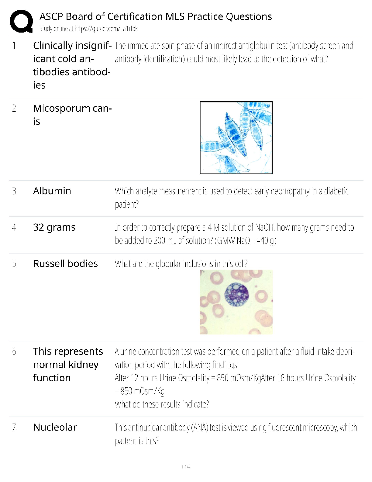
Document Content and Description Below
Web Mapping and GIS Final Exam Questions with Complete Solutions concept of standards and their use both outside of and for the geospatial industry Why have them? Be able to explain why important ... for web mapping and GIS ✔Ans✔Standards makes things more efficient and effective by establishing norms 19500 standards International Standards Organization Goals of standards is to communicate, execute programs, or transfer data with user having little or no knowledge Software engineered to work with different formats major standards organization for the geospatial industry and how it is comprised ✔Ans✔Open Geospatial Consortium Data, systems, and process standards Specific standards for many industries (aviation, energy, sensor webs) specific geospatial standards ✔Ans✔Geo(JSON) (Javascript Object Notation)- lightweight data interchange format KML (Keyhole Markup Language)-points,rasters,lines,polygons, defines visualizations WMS (Web Map Service)-standard for requesting and serving georeferenced map images over internet..how HTTP requests and responses are handled between client/server. rendered on the fly, WMTS (Web Map Tile Service)-predefined image files WFS (Web Feature Service)-standard for reading/writing vector geographic data WCS (Web Coverage Service)-retrieval of actual geospatial data GML (Geography Markup Language)- exchange standard, modeling language for geographic systems GPX (GS eXchange Format)- stores GPS data XML (eXtensible Markup Language)-standard for exchanging and storing data/documents there are data formats that are widely used but not necessarily adopted by standards organizations ✔Ans✔their specifications are published and open so software can be built to use them WMS and WFS ✔Ans✔Web Mapping Service and Web Feature Service WMS-standard for requesting and serving georeferenced map images over internet..how HTTP requests and responses are handled between client/server. rendered on the fly, WFS-standard for reading/writing vector geographic datacontrast WMS with WMTS ✔Ans✔Web Mapping Service- around longer, more flexible for returning custom georeferenced map images, clunky with potential for slower responses Web Map Tile Service-standard for delivering tiles, potentially reduces data and thus bandwidth...more efficient how WMS can be consumed by web mapping APIs and cloud-based web GIS ✔Ans✔Web Mapping applications can access WMS, sending requests for images (not tiles) that are rendered on the fly. when user zooms in a new image is requested. How text files can be used in some software (e.g. cloud-based - e.g. CartoDB, Google My Maps, etc.) ✔Ans✔Tabular data like CSV, Excel, Google Fusion Tables can be used. what they can do and how they are used varies. How we utilized data based on at least two of these standards in labs 4 and 6 ✔Ans✔GeoJSON with Leaflet API to look at iowa counties poverty CSV with CartoDB to look at twitter posts and animate them. What is Cloud Computing ✔Ans✔computer paradign for enabling on-demand network access to shared pool of configurable computing resources that can be rapidly provided and released with minimal management effort or service provider interaction Software on computers elsewhere (not personal computers) [Show More]
Last updated: 3 years ago
Preview 1 out of 8 pages

Buy this document to get the full access instantly
Instant Download Access after purchase
Buy NowInstant download
We Accept:

Reviews( 0 )
$8.00
Can't find what you want? Try our AI powered Search
Document information
Connected school, study & course
About the document
Uploaded On
Nov 19, 2022
Number of pages
8
Written in
All

Additional information
This document has been written for:
Uploaded
Nov 19, 2022
Downloads
0
Views
120


 Answered 2023.png)